Las Vegas/Hoover Dam
We headed north to pick up UT 20 to go over to I15. It was an up and down highway and when we
were at the highest, the truck thermometer indicated the outside temp as
33. We could see the condensation on the
outside mirrors begin to shine with ice.
We got on I15 and traveled the 35 miles south to Cedar City where we
picked up UT 56. Once clear of the city
limits, it became a narrow two lane state highway with trucks, buses, and RV’s
moving in both directions at 60 -65 MPH.
After 60 miles and upon entering Nevada it changed route names (NV 319)
and the road got a bit worse. Finally we
hit US95 and it was better, but was still 100+ miles of two lane. Once we hit I15 we only had to travel 10
miles to get to the Nellis AFB exit.
We did not realize until we checked into the campground that
we were now on Pacific Time. Once into
the base and campground we got ourselves setup and had some lunch. Boy was it hot!

We spent the rest of the day getting our bearings and
checking out the BX and Commissary. Both
are pretty big as this is the home base for the USAF Thunderbirds as well the Navy Top Gun
and Red Flag exercises (air to air fighter training).
Friday we were up pretty early so took advantage of the time
to do our laundry and pack up snacks and drinks for the day. We hit a quilt shop on the way. It was nice but things certainly were
pricey. Judy came away with a couple of
ideas though.
Before we got to the actual Hoover Dam, we stopped and
walked about half way across the Mike O’Callaghan - Pat Tillman Memorial bridge. You could get some good views of the dam from
the walkway along the westbound lanes of the bridge. This bridge was built as a
bypass to having traffic pass over the top of the dam.


After that hike we drove to the dam itself and paid $10 to
park and then another $12 each just to go in the visitor center. The visitor center was interesting and gave a
lot of history, but nowhere did it say how many men died in the dam. One sign noted that a number of deaths were
attributed to pneumonia! It was a marvel
of construction. Before they could even
start the dam they had to carve out four tunnels through the rock to divert the
river. These tunnels are fifty six feet
high and nearly ¾ mile long.
On the drive back to Nellis we passed a sign giving the
temperature as 113 degrees! By the time
we got back to the Open Range we were beat from the heat.
Saturday we decided to do the strip so we headed down Las
Vegas Boulevard. We picked a real
weekend to be here. Seems it is some
sort of a Mexican holiday and bus loads of folks from Mexico and local Latinos
are in the city. There was a big parade
going on and streets blocked off. We did
see the Pawn Stars Pawn shop, Trump tower and lots of other casinos. Actually we were not greatly impressed with
downtown Vegas.
Grand Canyon/Mesa
Verde
Sunday morning we were up and on the road out of the
heat. It was 80 degrees as we were
hooking up and the truck A/C felt mighty good.
We traveled the same roadways as we did going to Hoover Dam on our way
to the Nevada/Arizona line. This time we
stayed on US93 and crossed over that high bridge mentioned above. The scenery changed and became more flat, but
still a higher elevation. We tried to
get some pictures from the moving truck of the different boulders and rocks
along the way.

Once we hit I40 the rough ride began. I40 in Arizona has got to be the longest
stretch of rough interstate highway. We
thought I70 in Indiana westbound was bad but this is worse. Because of the time change on entering
Arizona (now on Mountain time) we got into the Canyon Motel and RV park at a
decent hour. As Sept 14 was our wedding
anniversary we had decided to go out for dinner. Rod’s Steakhouse was recommended but it was
closed on Sunday. Instead we opted to
head into beautiful downtown Williams on old Route 66.
Before dinner we checked out the downtown and some shops
before heading to Poncho Macgillacudy’s.
We enjoyed a nice Mexican dinner – and in fact brought some home.
This is our site at Canyon Motel and RV Park.

Monday morning we had a leisurely breakfast before heading
north to the Grand Canyon. The drive to
the park from where we parked took nearly an hour. Judy had read a lot about the park so we knew
pretty much what we wanted to do. We found a parking spot in the nearly full
lot and stopped by the visitor center, but the line up to speak with rangers
was quite long. So we opted to strike
out and walk the short distance to Mather Lookout. Once there we could see why it is called the
“Grand Canyon.”


We ‘hiked’ along the rim trail, stopping to admire the
expanse and dramatic views. At one point we happened upon an artist who was
just finishing a 12X15 painting of a tree.
This week in the park there are a number of artists painting park
scenery and views. The paintings are to
be sold at a gallery to help support art in the park.
We took so many pictures.


At the Bright Angle Trail head we headed down the steep
trail to the bottom. We had decided to
hike part way down…going all the way was too much. Actually the down part is not too bad, though
steep. It is the return trip as it is
all up hill. We hiked down and found a
nice spot to have a bite to eat. As we
were seated, three young ladies came hiking up and one asked if we wanted our
picture taken. She said we looked ‘cute’
sitting there.

 This is the trail back up, notice the droppings?


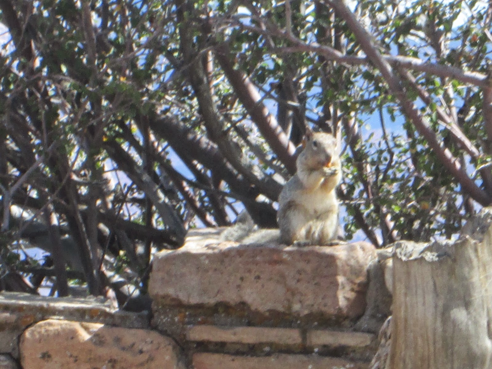
On our return to the top, we walked some more along the Rim Trail. We stopped near a lookout and found this squirrel begging for scraps.


At the train depot area we hopped on a shuttle for a reide back to the truck.
We were pretty tired by the time we got back to the truck – and had that drive back to Williams.
Before dinner we made one last trip into Williams to check
out the Quilt shop and pickup a couple of items at the Safeway.
Up early and had to finish packing up in slight drizzle but
by the time we were 30 miles down the road, it was dry and just cloudy. Once through Flagstaff we headed north on
US89. Just north of where the East
Entrance to the Grand Canyon we stopped at Cameron, Arizona This an old stone trading post and
hotel. We had just started browsing when
not one, not two but four tourist buses rolled.


This is the "old" suspension bridge that was part of the original US160.
A while later and further up the highway we came to the
“Four Corners” area where Utah, Arizona, Colorado and New Mexico meet. It happens to be on Navajo land and they have
set up a tribal park around it. We did
go in and wonder the four states. The
point is now surrounded on all sides by adobe like structures housing Native
American wares for sale.

We decided to try some “Indian Flat Bread” so stopped by a
stand outside the market area. Just
inside a young indian man was drawing indian designs on flat and semi-flat
rocks to be sold. As our bread was
frying we talked with him. When he
turned to us we could see that he was wearing a Cleveland Indians hat. Asked about his feelings on the subject of
the name, he said it was fine with him.
A little further north we turned off on it US160 and across
the Painted Desert area. Again the
landscape changed and you could see for miles.
Off in the distance were low mountains and bluffs long mesas and giant sandstone pillars.

As we approached Cortez the sky darkened and we could see
lightening bolts across the horizon. The
last ten miles in the campground was in a driving hard rain. It seemed to let up some as we led to our
site and we were able to get unhooked and mostly set up without getting too
wet.
This is our spot at Mesa Verde RV Resort – a little over a
mile from the main entrance to Mesa Verde National Park.

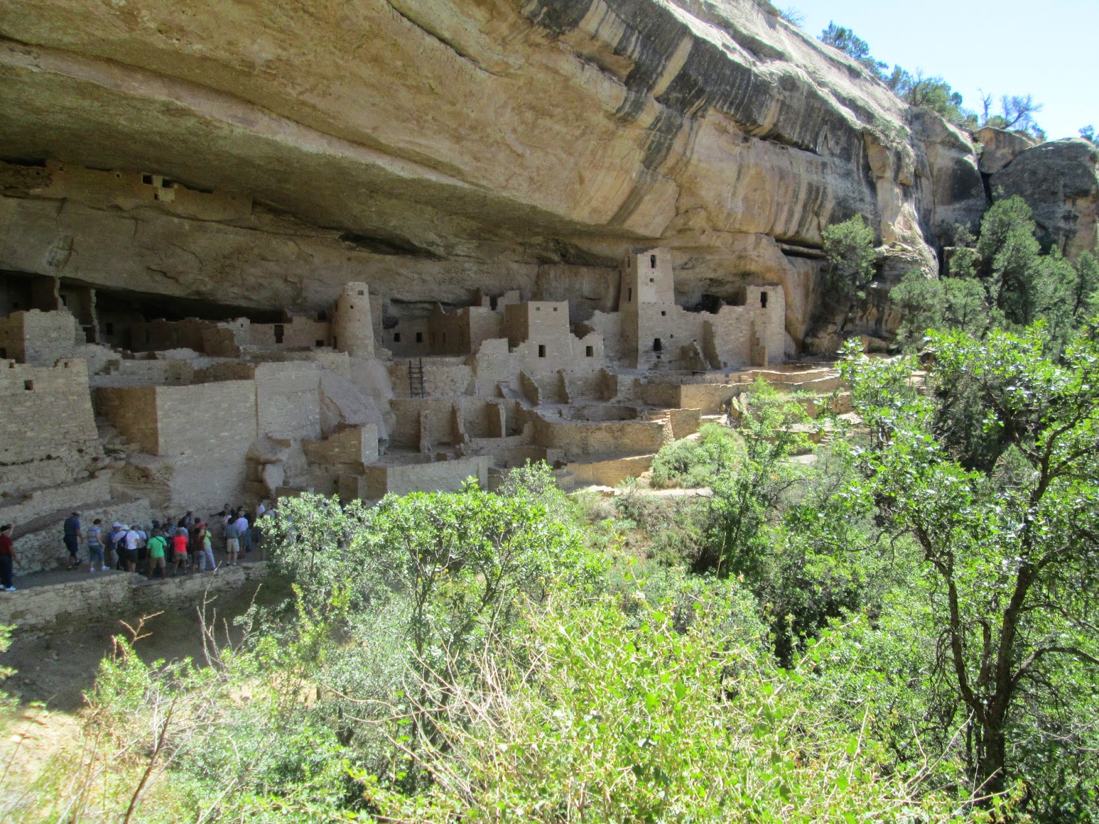
Thursday we headed to the park. When we arrived at the visitor center we
gathered some information and signed up for the 12:30 Ranger lead tour of Cliff
Palace. We had about two hours before
the tour so we had time for at least one hike because it is a 20 mile drive to
the dwelling sites. And it took every
bit of it as it was a real up and down drive along roads winding around the
mountain sides and down into valleys and back up again.


We had time to do the Soda Canyon 2 mile hike. At the end of the trail there are three
lookouts from which you can get spectacular views. From one we could see the Cliff Palace on the
opposite side of the mesa.


Judy thought she might find a unique dead cedar branch to decorate as a Christmas tree this year. But they were all too big to drag out, especially with so many people around.

At 12:30 Ranger Jim began our guided tour down 140 feet into
the dwelling area. It was a narrow and
steep climb and in some spots we were going down on steps cut into the sand
stone by the CCC. At the bottom we sat
on rock mostly in the sun as he gave his presentation on the history and what
we do know about the people who lived here in the year 1200AD.


We walked ito the area and gathered about a “Kiva” or round
house or building they used for religious or meeting ceremonies. In the center
was a fire pit and on one side and opening that led to a vent shaft on the
surface to bring in fresh air. As we
were preparing to move on, Judy feinted and dropped to the ground. The
combination of standing, standing in the sun, and the altitude got to her. It took several minutes but soon she felt
better and was able to stand. We moved
on a bit and the wooziness returned so we rested some more and opted to take
our time hiking up the steep trail and climbing the two wooden ladders.

Rather than taking any additional hikes we drove to the
Museum for a short film then a stop at a gift shop/camp store on the way out of
the park. On the way home we decided to
spend another night here and just take it easy. Saturday we head for
Albuquerque and begin the journey back to Ohio. But it may take a while to get there.